STUDY AREA3.1 MULLAPERIYAR DAM
The Mullaperiyar Dam is the first Surkhi concrete dam in a "V" -shaped gorge in the Western Ghats on the west flowing Periyar River. The Mullaperiyar Dam is having a height of 47.24 m (155 ft) above the river bed level of 0 (zero) ft and a length of 366 m (1200 ft). The total width at top including the original parapet was 3.66 m (12 ft). The front and rear faces of the dam are built with uncoursed rubble masonry in lime surkhi combination mortar of proportion 2.l:3. The proportion of lime surkhi mortar is two parts of lime, one part of surkhi and three parts of sand. The hearting, which accounts for more than 60% of the volume of dam is constructed of lime surkhi concrete with 3.125 parts of stone and 1 part of mortar. Later on, during the 1980s, a concrete backing of 10 m width was attached to the old dam on the downstream face as a measure to strengthen the old structure. The total width at the top after the strengthening has been increased to 6.4 m (21 ft). Thus, it is a composite heterogeneous structure comprising of rubble masonry on the upstream, lime surkhi concrete hearting (which accounts for more than 60% of the volume of the dam), again rubble masonry on the downstream, an ungrouted open joint and a 10 m concrete backing.
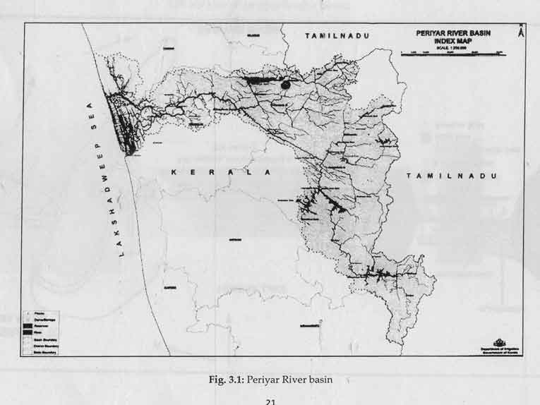
The Periyar River is a perennial river which rises from the Sivagiri group of hills in Kerala State and flows through this State and joins the Arabian Sea. Out of its total catchment of 5398 sq. km, 114 sq. km is located in Tamil Nadu far down the river from the Mullaperiyar Dam site and 5284 sq. km lies in Kerala. The maximum height of the Main dam is 53.64 m (176 ft). On both sides of the main valley, there are small saddles and the one on the left side was blocked by a Baby Dam of the same type with 73.15 m (240 ft) length and 16.15 m (53 ft) height which is connected to the high ground by means of an Earthen Dam. The saddle on the right flank is utilized as an escape channel and now serves as a spillway with 13 nos. control gates. The crest level of spillway is 867041 m. Later on, 3 more spillway vents were added with control gate each vent is of size 12.16 m x 4.88 m (40 ft x 16 ft).
There is an extremely huge quantity of Dead Storage provided merely to raise the remainder water to the level at which it can be passed through the tunnel into the Eastern side of the river watershed. The level of the sluice through which the water drawn by the Tamil Nadu is 15.75 m (48 ft) below the crest of the Dam which leaves a Dead Storage water depth of 41.01 m (125 ft) when full, the lake holds 553 MCM (15.661 TMC) of water out of which 324 MCM (9.176 TMC) is utilizable as it lies above the level of the sluice.
The rainfall occurs in 4 out of 5 days during June to November when the rain is practically continuous. Sudden floods from 283.17 to 3398 cumecs (or 10000 to 120000 cusecs) are constantly experienced during most of the year. Sometimes, 76.2 mm (3 inches) of rain is recorded in a period of 4 hours resulting in heavy floods. The project sanctioned in 1884 and started in 1887 was completed by 1895.
3.2 SALIENT FEATURES OF MULLAPERIYAR DAM AND ITS ALLIED STRUCTURES
Location
State: Kerala Latitude: 9°31'30" N Longitude: 77°8' 45" E
Reservoir
Catchment area: 624 sq. km Full Reservoir level: 46.33 m (152 ft) Maximum Water level: 47.24 m (155 ft) Gross Capacity of Reservoir: 443.23 MCM (15.662 TMC) Gross storage at 104 ft: 144.19 MCM (5.092 TMC) Gross. storage at136 ft: 317.43 MCM (11.210TMC) Gross storage at 155 ft: 470.54 MCM (16.617 TMC) Probable Maximum Flood: 8676 cumecs (306399 cusecs) Recorded Maximum Flood: 8453 cumecs (298519 cusecs)
Main Dam
Type Composite gravity structure, front and rear dam with uncoursed rubble in lime Surkhi mortar, core of dam (which forms to be about 62% volume of the dam) with lime surkhi concrete and 10 m wide concrete backing on the downstream as part of repair
Length: 366 m (1200 ft) Top of dam including parapet: 48.16 m (158 ft) Height of dam from deepest foundation: 53.64 m (176 ft) Top width of dam with parapet: 6.4 m (21 ft) Downstream slope: 0.9276 to 1.0 Upstream Slope: 1 to 20
Spillway
Location: Right Saddle Crest level: 41.45 m (136 ft) Number of vents (old) : 10 in Nos. with size 10.98 m x 4.88m (36 ft x 16 ft) Number of vents (additional): 3 in Nos. 12.16 m x 4.88 m (40 ft x 16 ft)
Baby Dam
Location: Left Bank saddle Type: Composite gravity structure Top of dam: 48.17 m (158 ft) Length of dam: 73.15 m (240 ft) Height of dam 16.15m (53 ft)
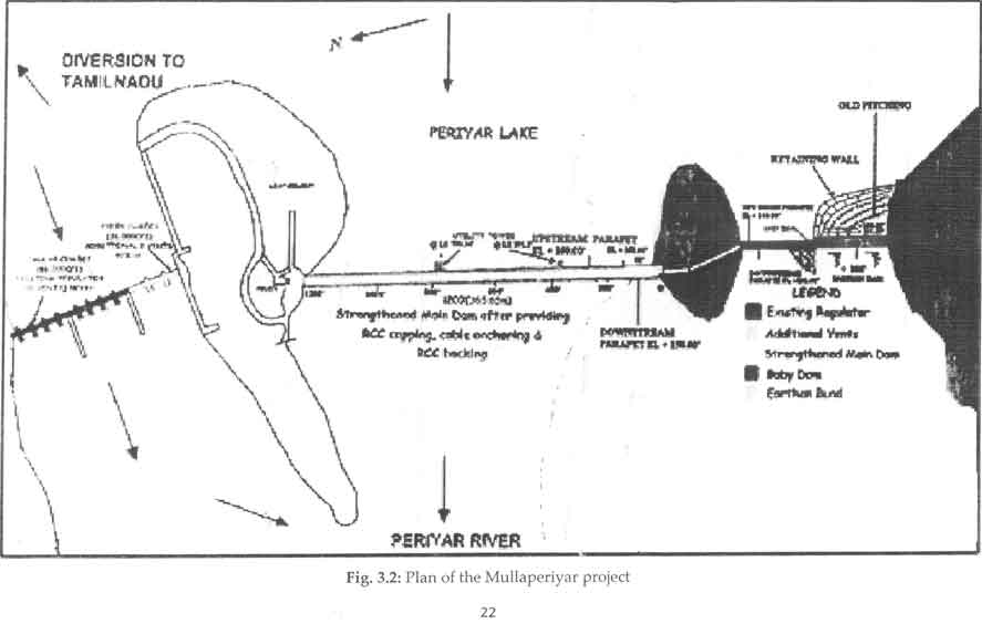
Fig. 3.1 shows the Periyar river basin indicating the location Mullaperiyar dam, Fig. 3.2 the plan of the Mullaperiyar project, and Fig. 3.3 the cross section of Mullaperiyar Main Dam.